

Impacts of the internal and external displacement waves on the Egyptian Cities
Yehya M.Serag
[1] Yehya M. Serag is an associate professor of urban and regional planning- Faculty of Engineering – Ain Shams University – Yehya_serag@eng.asu.edu.eg
1. Introduction
In recent years and with the ongoing conflicts, political instability and revolutions that took and are still taking place in different parts of the world; different waves of displacement and migration have been taking place. These waves usually affect the transition and destination countries in terms of the impacts made on their cities by the settling displaced population. However, the countries of origin are also affected in a later point with the challenges of settling back the returnees.
This research looks at the different waves of displacement that occurred over the last 100 years and affected the Egyptian cities. Egypt has always been considered as the cross roads for many migration waves throughout history, some waves just passed through Egypt, while others considered Egypt as their final destination. The country was not only subjected to external displacement waves, but it also witnessed several cases of internal displacement as results of war and in other cases as collateral impacts of mega development projects. The research attempts to track down most of these waves and investigate mainly their spatial impacts and highlight other impacts on the host cities.
1.1 Research Methodology
The research sets a timeline starting from 1915 with the cases of the Armenian refugees who reached for Egypt as a result of the genocide that was inflicted to them by the Ottoman empire. It then looks at the Greek and Yugoslav refugees and migrants as a result of the second world war. It investigates afterwards the three major cases of Internal displacement in 1956 because of the Suez War, in 1964 because of the construction of the High Dam and in 1967 as a result of the six days war. This is followed by an overview of the impact of the Iraqi migrants in the 2000s who migrated to Egypt as a result of the invasion of Iraq in 2003. The final wave came with the Syrian migrants and refugees who settled in Egypt after the Arab Spring revolution that occurred in Syria starting from 2011 and escalated to a state of an armed civil conflict afterwards. The research did not cover the case of the Palestinian refugees although it occurred across several decades because of the complexity of the case, which could be further discussed in a separate research. It also did not investigate the different cases of illegal migration and their spatial impacts as they are not among the scope of this research. Mainly the research followed the timeline discussed above and was conducted through holding interviews with relevant persons, who witnessed these incidents or in some cases their descendants. A proper literature review was also made as well as the use of available documentation materials of photos, films, etc.
1.2. Research Constraints
It is important to consider that since the time frame of the research extends over a period of 100 years, and that some displacement waves took place over 70 to 100 years ago, in some cases enough documentation was not found. Moreover, many of those who witnessed the displacement processes had passed away, hence it was a bit difficult to find first account information as in the case of the Armenian refugees. It was possible however, to get some information from their descendants.
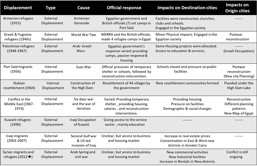
The research concludes with a matrix showing the different displacement waves that occurred to and inside Egypt within the timeframe. It shows their types, causes, the official responses to them as well as the impacts on the destination cities and the known impacts on their origin cities if possible. In doing so the research provides some lessons that could be learned from the Egyptian case to be shared with other countries in present times facing different waves of migration, in a process of mutual learning among nations.
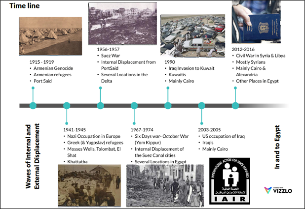
Figure 1: Timeline of the waves of internal and external displacement in Egypt
Source: Author
2. Types of Displaced People used in the research
Indeed, there are many types of displaced people, which are classified according to different criteria. This research focuses mainly on three types of displaced persons, there would be migrants, refugees and internally displaced people.
According to the International Organization for Migration (IOM, 2016), a migrant is any person who moved or is moving across an international border or a state away from his/her original residence, regardless of his legal status, causes of movement, duration of stay and whether this movement was voluntary or not. In this paper the word “Migrant” is used to refer to persons who crossed the international border in normal legal ways.
According to the UN refugee agency (UNHCR, 2016), a refugee is someone who was forced to flee his country because of persecution, war or violence. There are of course different causes for these three types that might have to do with religious, ethnic, and nationality conflicts for examples. As a result, the refugees cannot return home because they are afraid to do so.
As for the Internally Displaced Persons (IDPs), they are people who are forced to flee their homes but never cross an international border. They can seek refuge in other towns or villages, forests or fields etc. They are citizens in one country who are displaced because of conflicts or natural disasters (ibid) and in this paper the causes will include mega national projects and force majeure.
3. Numbers of Internal and External Displaced Persons in Egypt over the last 100 years
Following the timeline mentioned above, it was possible to make a map showing the origin countries from which the refugees came from, as well as the numbers of the internally displaced persons of some cases in Egypt. The numbers shown in the map, reflect mostly the official numbers of registered refugees, however, in many cases, these numbers would increase if the unregistered ones are added.
Many of the Syrian, Libyan and Iraqi nationals in Egypt who fled the conflict zones, would not register as refugees, since they entered the country through a legal travel path as many of them were wealthy enough not to ask for any financial assistance. As such, the numbers shown on the map should drastically increase if both numbers of refugees and legal migrants are considered.
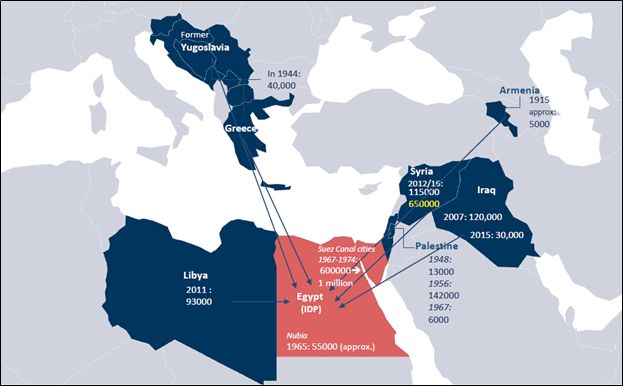
Figure 2: Map showing the numbers and origins of the refugees who came to Egypt, as well as the numbers of the Internally displaced persons in Egypt over the last 100 years.
Source: Author with information adapted from official websites including UNHCR.org
4. Waves of Refugees to Egypt in the first half of the 20th century
During the first half of the 20th century Egypt witnessed waves of European refugees during both World Wars. The earliest of these waves was that of the Armenian refugees that started in 1915. This was followed by a larger wave that came quarter of a century later with the Greek, Poles and Yugoslav refugees who came to Egypt as a result of the Nazi occupation to many European countries. These two waves are discussed in the following sections.
4.1. Armenian Refugees in Egypt: 1915
During the events of World War One, the Armenian Genocide conducted by the Ottoman Empire, came to climax in 1915 with the murder of 1.5 million Armenians living within the Ottoman Empire (Lea-Henry, 2015) causing thousands of Armenians to flee their country.
According to Koloyan-Keuhnelian, (2015), in April 1915, about 5000 Armenians were rescued by French and British navies, after their escape from violent operations by the Ottoman forces. The Armenian refugees were granted asylum in Egypt after being declined elsewhere, specially that Egypt at that time was a British protectorate. The refugees were hosted in a camp in Port Fouad by the Suez Canal, afterwards many of them decided to settle in Egypt, mainly in Cairo and Alexandria, while others moved to other countries. The number of Armenian refugees increased afterwards to reach 17000 people by 1927 (Zohry, 2005).
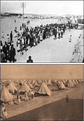
Figure 3: Armenian refugees’ camp in Port Fouad – Egypt , 1915. Source: Knapp (1919).
Owing to the fact that both Armenia and Egypt were part of the Ottoman Empire for more than 400 years, Armenians did not face significant problems in moving and settling down in Egypt. This is evident from the period pre-1915, specially that at a certain point of history, Nubar Nubarian Pasha who served as a Prime Minister of Egypt between 1878 and 1895 for three times was Armenian. Accordingly, the Armenian refugees post 1915 did not face significant problems as well in merging with the Egyptian society (ibid).
Many Armenians played influential roles in the Egyptian society in art, cinema and journalism. The Armenian population kept increasing in Egypt, until the 1950s. However, as a result of the political change that came with the 1952 revolution, several economic and social impacts took place within the Egyptian society causing a reverse migration of several population groups including the Armenians (Zohry, 2005). Currently there is under 12000 Armenians currently living in Egypt (Marefa.org, 2016).
Physical impacts on the built environment
Significant impacts on the Egyptian cities in Egypt were not visible, except for the few community buildings that they built. Mr. Kalinian, an Armenian Egyptian , explained through an online interview that the Armenians settled in the cities of Cairo and Alexandria and other locations in the South of Egypt.
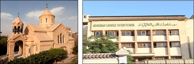
Figure 4: Armenian church and Armenian school
Source: Abdel-Massih (2015).
Normally they settled in locations that already had earlier settling of Armenian population. They lived however in apartment buildings mixed with the Egyptian residents. He explained that since there was already a presence of Armenians in Egypt before 1915, the Armenian refugees used the already existing community buildings and later constructed more buildings in the years that followed. The constructed buildings were mainly the Armenian Cathedral, schools and social clubs in the cities where they settled.
4.2. Greek and other European Refugees in Egypt 1941-1945
During the events of World War Two, and Nazi conquest of Europe, a significant influx of refugees from Europe to the Middle East took place. Greek and other European refugees (Poles and Yugoslav) fled or were deported to Egypt starting from 1941. In 1944 an estimation of 40000 refugees was recorded in Egypt alone mostly sheltered in refugee camps. Other refugee camps were set in other locations in the Middle East, including Syria and Palestine (Taparata and Ser, 2016). The first refugee camp to be set was overwhelmed by 1800 refugees per week, which led to the setting of other camps of which four were in Egypt as shown in the map (Abu Mrad, 2016). These camps were operated by the Middle East Relief and Refugee Administration (MERRA) according to the United Nations archives.
In this case as well, there had been a significant Greek Community living in Egypt before the start of the second world war. Egypt and Greece had strong historical ties to the extent that the Greek government in exile during the war operated from Cairo. As such similar social and physical impacts to that of the Armenian refugees took place.
The Greek refugees who arrived in the 1940s either stayed in the camps till the end of the war and returned home, or some of them settled in Egypt to join the Greek-Egyptian community that reached its climax of 140000 inhabitants by the early 1950s (mfa.gr , 2016), this number started to decrease afterwards mainly after the 1952 revolution in Egypt. Those who settled worked in different sectors mostly in Alexandria and Cairo.
Already, there had been several Greek buildings and facilities mainly in Alexandria, before the war. Unfortunately following a reverse migration process in the decades to follow, the Greek population in Alexandria is now below 2000 inhabitants (Shawky, 2012).
5. Internal Displacement in Egypt
Egypt became subject to some cases of internal displacement of portions of its population throughout the 20th century. The following sections discusses three main internal displacement cases, these are: the displacement of the Nubian population in 1964 as a result of the construction of the High Dam in Aswan, the displacement of the population of Port Said city during the Suez War in 1956 and the internal displacement of the residents of the Suez Canal cities between 1967 and 1974 as a result of the Six Days War in June 1967. The Nubian case is discussed first since its causes are not conflict related, while the other two cases that are conflict related are discussed afterwards.
5.1.The Nubian resettlement (IDP) – 1964
During the 1960s Egypt constructed the High Dam in Aswan in the South of Egypt. This project was considered a mega national project that aimed to control the Nile Flooding, avoid the annual despair of that flooding, to have a reasonable reservoir of water and to generate electricity.
The decision was made to adopt the Soviet solution of the Dam. The Dam was to form a lake behind it that became later known as Lake Nasser and of an area of about 350 Km2 that extends both in Egypt and Sudan. The formation of the lake meant that the Nubian villages that were in that place will be flooded and end up submerged under the lake (AL Soghayer, 2010). As such the population of 42 Nubian villages, about 55000 inhabitants, had to be evicted to another location in May 1964 (Serag, 2013). This eviction is argued to be the large forced internal displacement in Egypt in Peace times. The displaced Nubian population was resettled in newly built villages in Komombo, almost 50 kilometers to the North of the original location of their villages (ibid).
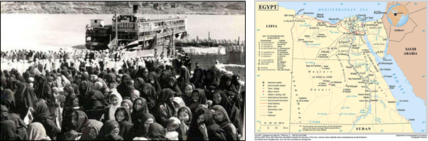
Figure 6: 1- Displacement of the Nubian population to Komombo as a result of the construction of the High Dam in the South of Aswan. The location of Aswan is 50 Kms North of Aswan.
Source: nobaa.com , 2016
Physical Impacts
The Nubian resettlement led to the relocation of an entire region. The inhabitants of the 42 settlements were housed in newly planned settlements in Komombo. However, in terms of housing typologies, the new villages came as a disappointment to the Nubian migrants. According to Serag (2013) the Nubian villages were mostly overlooking the Nile, the main activities of the Nubian population were agriculture and to a lesser extent fishing. Their new planned villages were located 10 kilometers away from the Nile and almost into the desert hinter land of the Nile Valley.
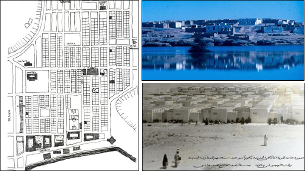
Figure 7: Left: a new plan for the resettlement villages,
Top right: An original Nubian village before May 1964,
Bottom Left: A resettlement village with the Nubians moving in post May 1964.
Source: clockwise: 1- Mahgoub, 1990 , 2- Zigler, 1964 , 3- noobaa.com, 2016
This resulted in a drastic change in terms of the nature of their habitat which also affected their economic activities and daily lives. The authentic Nubian house was known for its spacious design and multi-rooms and special treatments of facades. The new housing prototypes were totally different from the original ones; with much lesser floor area and floor plans that came as a disappointment to the Nubians (Kamel and Abdel-Hadi, 2012). As such, the impacts of this displacement to most of the Nubian population were very drastic. A stark change in their habitat from a Nile attached life to a more like desert life, affected their social and economic lives. Changes in activities, increase in the rates of unemployment, as well as the gradual loss of language and culture are tangible (Serag, 2013). After more than 50 years of the displacement process, the Nubian resettlement is still a highly controversial issue, with Nubians demanding the right to go back closer to their original habitat.
5.2. The Suez War – Fleeing Port Said – 1956
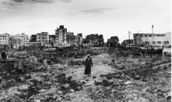
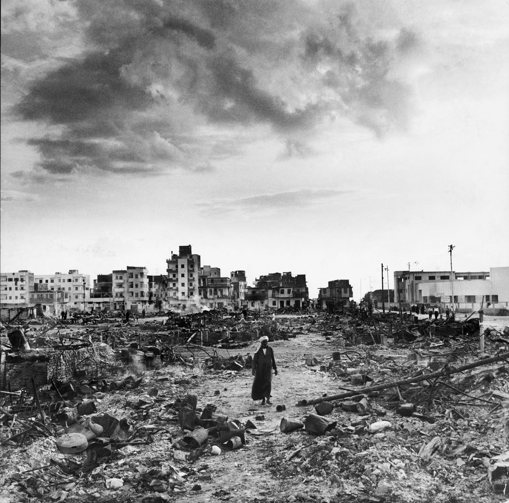
Figure 8: Port Said city in the aftermath of the 1956 Suez Crises that was locally known as the Tripartite Invasion
Source: tumblr
In the first half of the 1950s, and following the 1952 revolution in Egypt, the government planned for constructing a Dam in the South of Egypt to control the annual flooding that usually caused devastation, and to have a controlled reservoir of water. Initially, the United Sates and the United Kingdom agreed to fund the Dam construction project, however this offer was withdrawn later because of political disputes concerning the armament of the Egyptian army at that time. As a result, president Naser nationalized the Suez Canal which was under international administration and control since its opening in 1869.
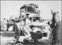
Figure 9: Crossing El Manzala lake to reach for safer cities in the Delta- 1956
Consequently, the United Kingdom, France together with Israel attacked Egypt to regain control of Suez Canal in October 1956, hence, starting the Suez Crises (BiblAlex.org, 2016). Most of the Military operations were concentrated in the Suez Canal region as well as Sinai, with the city of Port Said turning it into a battleground, causing heavy damage to many of its districts. Although there was no official decision for eviction, many families fled to other locations in Egypt , mainly the Delta. As explained by Mrs Amina Awad, an eye witness to the Suez crises and one of the fleeing population in 1956, families had to cross EL Manzala lake to reach for safer cities and villages in the western part of the Egyptian Delta.
Physical Impacts
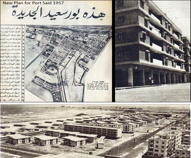
Figure 10: Top Left: The New master Plan for Port Said 1957. Top Right and Bottom: Newly constructed districts according to the plan after the Suez Crises.
Source: protal9journal.org
In this case, the physical impacts on the host cities were temporary. As explained by Prof. M. Serag and Prof. M. Adly who were interviewed for this research, many of the displaced families were given shelter in schools and in some occasions hosted by local families. The temporary displacement lasted only for few months starting from November 1956 till the first quarter of 1957, when civilians started moving back after the end of hostilities. The main physical impact that took place was on Port Said city itself with the post war reconstruction intervention. Due to the severe destruction, a new Master plan for the city was made and the reconstruction of the damaged districts took place, giving way to a new image of the built environment in different districts in the city. A Similar scenario to that of 1956 was repeated eleven years later with the outbreak of the Six Days War in June 1967, however, this time the impacts were far deeper.
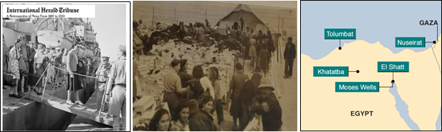
5.3. Aftermath of the Six Days War: Suez Canal Cities’ Deportation – 1967-1974
As a result of the Six Days war in June 1967, Israel occupied the Sinai Peninsula and stopped by the East bank of the Suez Canal. This made the Canal cities (Ismailia, Port Said and Suez) on the frontline of confrontation. According to eyewitnesses’ accounts as well as documentation material from that period, the residents of these cities suffered many casualties, because of the military confrontation that took place. According to Mr. Gamil Yousef a former resident of Ismailia, by August 1967, a governmental decree was taken to evict the civilians from the Suez Canal region, i.e. the three cities, for their safety. The number of the displaced population was estimated to be between 600000 and 1 million inhabitants (Algendy, 2014). They had been evicted from the Suez Canal Cities, and were only allowed to return after the conclusion of the following war (October War or Yum Kippor War) in 1973.
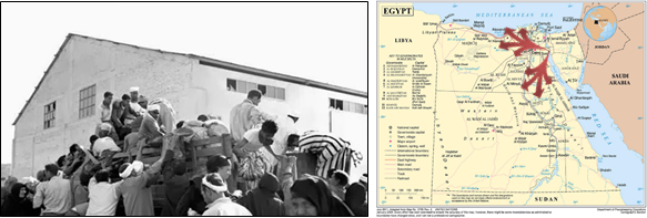
Figure 11: Displacement Caused by the 1967 war, and the evacuation of the Suez Canal Cities
Source: akhbarelyoum.com ,
Physical and other Impacts
The displacement of the Suez Canal cities residents had tangible impacts on both the displaced people and the cities that hosted them. As described by some living witnesses from that period (Mr. Gamil Yousef and Mrs. Amina Awad), the residents had to evacuate the cities in August 1967 after the increase in civilian casualties due to military operations and raids on the cities.
They were evacuated in lorries that took them to safety in other cities in Egypt. The evacuated families were initially hosted in schools, where the classrooms sheltered more than one family and partitioned by bed sheets. Following that initial period several scenarios took place: The families rented a place to live, in some cases in the summer huts in coastal cities such as the city of Ras El Bar. Other families were hosted by local families for a period before finding another place to rent or live in. While others were hosted by their relatives in other locations in Egypt. As explained by Prof. Serag and Prof. El Adly, employees of the public sector for, example the Suez Canal Authority, were housed in government owned housing projects in other cities. It is to be mentioned also that many refugees from Gaza strip were given homes in housing projects in cities like Cairo.
Figure 12: Osman Buildings in Nasr City – Cairo, were allocated to host displaced people in 1967
Source: flicker.com
This is because, Gaza Strip was under the Egyptian administration since 1948 until the outbreak of the
six days war. As such the action in terms of hosting the refugees is can be explained from as a result of the Pan Arabism doctrine that President Naser followed at that time.
The displaced population was distributed among the Egyptian cities, however, 5 main governorates (provinces) in the North of Egypt received much of that population. These governorates are Sharkeia, Dakhalia, Damietta, Cairo and Giza. It is to be mentioned also that there was a remarkable pressure on service facilities in the host cities, such as schools and health care services, that had to deal with both the original residents and the displaced population. With such a large number of IDPs , the demographic structure and population size in the host cities were in most cases affected drastically. As explained by the interviewees, many of the IDPs who did not own their places of accommodation, i.e. rented their houses and flats, never went back after the end of hostilities in 1974. However, the majority of those who owned their homes returned to their cities after the end of the war period.
The Suez Canal cities were deserted (except for war effort) for six years with no maintenance or sanitation, leading to excessive damage to their infrastructure and buildings. As well for the outbreak of rats. Many buildings were damaged during the period between 1967-1974, to the extent that the image of the cities was highly changed afterwards during the post conflict reconstruction period.
Suez Canal Cities (IDP): the return- 1974 onwards
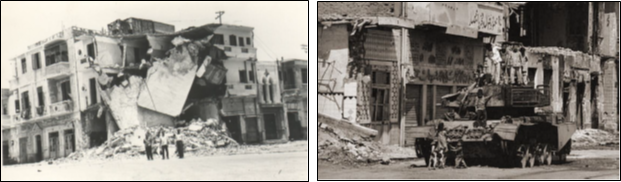
Figure 13: Damaged and destroyed buildings in the Suez Canal cities , were either repaired or replaced in the aftermath of the Wars, leading in many cases to a change in the original image of these cities
Source: 9gag.com
After the seize fire in 1974 following the October war (Yom Kippur), president Sadat authorized the start of the return of the IDPs of the Suez Canal cities.
It took several years for the reconstruction process to achieve its objectives. In October the same year, Sadat administration issued the so-called October Working Paper, which included two main strategy lines: the first was geared towards economic reform through what was known as the Open Door Policy “Infitah”; while the second was focused on the urban development, by introducing the New Map of Egypt (Attia, 1999).
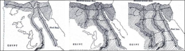
Figure 14: The three phases of the New Map Policy (October, 1974) with the development of the Suez Canal cities and Sinai falling within the first phase.
Source: Attia, 1999
The New Map of Egypt focused mainly on increasing the inhabited area of Egypt to come out of the crowded and narrow Nile Valley, to an increased inhabited space across Egypt. The New Map pivoted on using the concept of development corridors to achieve the objectives (ibid). Among the first priorities was the reconstruction of the affected Suez Canal cities to allow for the return of the IDPs, which indeed was done in the years to follow.

Figure 15: Repairing of the damaged buildings in the Suez Canal Cities after the War.
According to the interviewees, the government aided the citizens in several cases in restoring the damaged buildings, when their structural conditions allowed for that. In other cases, returning citizens lived in bunkers until their homes were fixed or rebuilt. In some cases, new districts were planned and reconstructed to provide housing stock for the returning population.
Source: eldameer.com
An example for this is Sheikh Zayed District in Ismailia city. Following the war, Sheikh Zayed the leader of the UAE decided to contribute in the post war reconstruction process by offering to support the construction of a new district that attracted back many of the displaced population (albayan.ae, 1998).
Despite the attempts that were made for the postwar reconstruction, it is argued that an undoable change in the demographic structure in both the evicted and host cities were done.
6. Waves of Refugees to Egypt between 1990 until present
Over the last three decades Egypt witnessed different waves of displacement mainly from the Arab countries as a result of regional wars and civil armed conflicts. The three main waves of that period are discussed in the following sections.
6.1. The Second Gulf War: Fleeing Kuwait -1990
The following wave of displacement took place between 1990 and 1991, after the Iraqi invasion of Kuwait in August 1990. Many Kuwaitis and other nationalities fled Kuwait in convoys. They took different paths such as crossing from Iraq to Kuwait then to Jordan before reaching the host countries including Egypt. However, this displacement case was short lived as Kuwait was liberated in February 1991and most of the displaced people returned. Egypt received at that time a sudden flow of Kuwaitis as well as Egyptians working in Kuwait.
As explained by one of the Egyptians who was living in Kuwait during the invasion and had to flee to Egypt afterwards, a direct physical impact was not felt in the housing sector as the Egyptians returned to their homes while the Kuwaitis managed to rent apartments for their stay. Perhaps the educational facilities were the ones that were most affected, since some schools had to work double shifts to accommodate the displaced pupils at that time.
6.2. The Third Gulf War: Fleeing Iraq – 2003-2007
The US led invasion of Iraq and the spread of sectarian violence afterwards, caused many Iraqis to seek refuge in other safer countries. According to the interviews held with Iraqis, in the years that followed the invasion there was an increase in tensions between Sunnis and Shias to the extent that people were targeted based on their religious affiliations. Accordingly, many Iraqis left their country with roughly 150000 Iraqis resettling in Egypt since that time (Ibrahim, 2008) . Such a resettlement that was mostly made by affluent Iraqis caused an increase in real estate prices, especially in the new districts and cities of Greater Cairo Region. A reverse wave of moving back to Iraq, started in the late 2000s, however the impact done on real-estate sector was irreversible.
6.3. Syrian migrants and refugees: 2012-present
The outbreak of the revolution starting from December 2010 in Tunisia sparked a wave of revolutions in several countries in the Middle East that became known as the Arabic Spring Revolutions. The revolutions extended to Egypt, Libya, Yemen and Syria. In Syria, what started as a revolution in the beginning against the ruling regime soon transformed into an armed civil conflict in the country, which led to one of the largest displacement waves in the Middle East in recent history and in the 21st century. Syrian civilians started to flee the conflict zones and seek safe refuge in neighboring countries as well as European Countries reaching millions in numbers.
Egypt was one of the destinations for the Syrian migrants and refugees since 2012. Perhaps having the same language and a similar culture as well as common history were the reasons for them to move to Egypt. The Syrians are quite visible and accepted in Egypt, with many students in the Egyptian universities and schools. Based on the interviews conducted with Syrians who moved to Cairo in 2012, there are two types of Syrians residing in Egypt, the first type is those who decided to move to Egypt with their capital when the conflict started. Many of them started businesses and settled in Egypt through formal means, those could be called the migrants. While others who fled the conflict seeking refuge with no money or capital with them registered as refugees at the UNHCR. The Official numbers of Syrian refugees in Egypt count for about 135 thousand .in 2014 (Grisgraber, 2014). However, the total number of Syrians in Egypt is much larger than this number, with unofficial estimations that can reach up to 650000.refugees if not millions.
Physical and Other Impacts on Egyptian cities
It is important to note that there is an ongoing increase in the researches carried out in relation to the Syrian refugees and migrants in Egypt and their impact on the Egyptian cities. The intention of this research is to highlight the presence of the Syrians in Egypt as the most recent wave of displacement and the largest in the 21st century, without getting deeper into details, as this is done elsewhere.
The Syrian population settled in several Egyptian cities, although their largest concentration is argued to be in Greater Cairo Region followed by Alexandria. The presence of the Syrians in Egypt is evident in their economic activities and the opening of several Syrian small businesses that are mostly related to restaurants, as well as other handy man services. Astonishingly. In some Industrial cities in Egypt such as 10th of Ramadan and Obour cities, the affluent Syrians managed to move their textile industries in these new locations, which in terms benefited the Egyptian economy (based on the explanation of the Syrian interviewees).
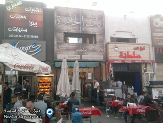
Figure 18: Syrian Shops in EL Rehab city and a major increase since 2012
Source: Newcairodirectory.com
It was noticed that well off Syrians are either concentrated in New Cairo or 6th of October cities in GCR. It is argued that this division might be because of political reasons among them. In that sense it depends on which side of the Syrian conflict do each group of Syrians support. For example, those who support the current Syrian government settled in the East of the Greater Cairo Region in New Cairo City, while those who are counter government and pro-revolution settled in 6th of October city (Ayad, 2016). However, this argument cannot be fully justified because of the rapid changing settings on the ground and the mingling of the Syrians within the Egyptian population.
It is argued that the presence of Syrians in the Egyptian cities left noticeable visual impacts on the places of their concentration. An example is shown from one of the gated communities in East Cairo, El Rehab City, where there is a large concentration of Syrians renting both apartments and shops. The Syrian presence is evident in relation to the commercial activities and can be sensed clearly from the shop signs, odors and shops’ settings. Another example is also evident in the 6th of October city to the west of the GCR, where a market street close to El Hosary square, was totally transformed to be locally known as little Damascus (Primo,2015). Among the tangible impacts as well is the emergence of Syrian – run schools, where the schools follow the Egyptian curriculum but are run by Syrian teachers to preserve the dialects and habits of the Syrian community within their children.
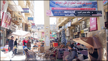
Figure 19: Little Damascus in 6th of October City – GCR
Source: Egyptian chronicles
The less affluent Syrians and many cases who happen to be registered as refugees, receive help from charity organizations in Egypt and were settled in some emergency housing locations.
7. Conclusion
Although the waves of displacement and migration have increased drastically in the global level, similar waves happened before in different locations and countries throughout the last 100 years. This paper attempted to highlight the waves of displacement and migration that occurred in Egypt through a period of 100 years. Egypt was not only affected by waves of migration and refugees but was also affected by several incidents of internal displacement that reached in some cases 600 thousand to one million IDPs (as a result of the six days war).
A conclusion matrix (Figure 20) is presented to show the different cases and their impacts on the Egyptian context. In the cases discussed, the impacts of the waves of displacement on cities varied between positive and negative impacts according to the size, circumstances, and contextual settings of the displacement wave. In terms of the European waves of displacement including the Armenians, and the Greeks, the number of refugees who arrived in Egypt did not exceed several thousands as a result of the mesmerizing events of the Armenian genocide and the Second World War. After these events ended, they either returned to their countries or other European countries or stayed in Egypt. Those who stayed managed to live within the Egyptian society, while constructing their own cultural, religious and educational facilities. The most recent wave of Syrian displacement coming to Egypt, had mostly positive impacts on the local society and economy. Perhaps because of the similar cultural and language the Syrian migrants and refugees managed to somehow integrate within the Egyptian society and mostly the Egyptian economy, which received significant inputs with an increase in competition, that benefited the economy as a whole.
This situation is perhaps different if compared to the impacts of the Syrian refugees in European and other MENA countries. Their impacts are questionable in most cases because of the cultural, language and religious differences. There were of course other migration and displacement waves that had negative impacts on the housing sector, most notably the Iraqi wave that caused a significant increase in housing prices. But the most devastating waves of displacement are argued to be those of the IDPs within Egypt, with the Nubian case which caused social and cultural damage to the Nubian population. The major negative impacts were because of War, especially the six days war, which caused the relocation of almost 1 million inhabitants and changed the demographic structure in many cities for years to follow with its repercussions still resonating until present day.
This paper reflected on the different waves of displacement that Egypt experienced, in an attempt to make a contribution and present the lessons learned to the international discussion on the migration and refugee questions that are currently present in many countries.
References
- IOM, 2016, Who is a migrant? , available online: https://www.iom.int/who-is-a-migrant , accessed July 2016.
- UNHCR, 2016, What is a refugee?, available online: https://www.unrefugees.org/refugee-facts/what-is-a-refugee/ , accessed July 2016.
- Lea-Henry, J., 2015, Why the Armenian genocide matters?, available online: http://www.onlineopinion.com.au/view.asp?article=17314 , accessed: July 2016
- Koloyan-Keuhnelian, N., 2015, Refugee remains revived in Port Said, available online: http://weekly.ahram.org.eg/News/13558.aspx , accessed: July 2016.
- Zohry, A., 2005, Armenians in Egypt, paper published in the proceedings of the conference of the International Union for the scientific study of population, Tours, France.
- Knapp, G., 1919, The tragedy Bitlis, republished in 2015 by Creative Media Partners.
- Marefa.org. 2016, Armenians in Egypt, available online: https://www.marefa.orgالارمن_فى_مصر , accessed July 2016.
- Abdel Massih, S., 2015, Egypt’s Armenians, available online: http://en.wataninet.com/features/features_1/egypts-armenians/13602/ , accessed July 2016.
- Taparata, E., and Ser, K., 2016, During WWII, European refugees fled to Syria. Here’s what the camps were like, available online: https://www.pri.org/stories/2016-04-26/what-it-s-inside-refugee-camp-europeans-who-fled-syria-egypt-and-palestine-during , accessed: July 2016
- IHT, 2016, Greek refugees reach Cairo, Available online: https://iht-retrospective.blogs.nytimes.com/2016/04/ , accessed July 2016.
- Abou Mrad, N, 2016, The Greek refugees who fled to the Middle East in WW2, available online: https://www.bbc.com/news/world-europe-36499727 , accessed July 2016.
- Mfa.gr, 2016, Cultural relations and Greek community: Greece and Egypt, available online: https://www.mfa.gr/missionsabroad/en/egypt-en/bilateral-relations/cultural-relations-and-greek-community.html , accessed July 2016.
- Shawky, A., 2012, Communities: Egypt’s Greek Legacy, available online: https://ww.egyptindependent.com/communities-egypts-greek-legacy/ , accessed July 2016.
- Al Soghayer, A. , 2010. Nubia and Lake Nasser: Secrets and Monuments, Agyal, Cairo.
- Serag, Y., 2013, Nubian Resettlement Challenges: Between past memories and present settings, paper published in the proceedings of the Sustainable Building 13 (SB13) conference, Cairo.
- Kamel, D. and Abdel-Hadi, A., (2012), Space, Color and Quality of Life in a Nubian Environment, in International Journal of Architectural Research (IJAR), vol. 6- Issue 1, MIT
- Mahgoub, Y., 1990. The Nubian experience: A study of the social and cultural meanings of architecture, Published PhD. Thesis, The University of Michigan, USA.
- Zigler, K., 1964, Photos taken on site from old Nubia.
- Bibliotecha Alexandrina (BibAlex.org), History of Modern Egypt: Opening of the High Dam, http://modernegypt.bibalex.org/Types/Events/Details.aspx?ID=iCyW0PueT4HIif%2fODeQGJg%3d%3d (accessed June 2016).
- AL Gendy, I., 2014, Suez Canal Residents left their homes and supported the army in three wars, available online: https://alwafd.news/ملفات-سياسية/765589-سكان-القناة-هاجروا-من-بيوتهم-ودعموا-الجيش-فى-3-حروب accessed in July 2016
- Attia, A., 1999, Planning for sustainable tourism development: An investigation into implementing tourism policy in the North-West coast region of Egypt, unpublished PhD thesis, University College London.
- https://www.albayan.ae/last-page/1998-08-07-1.1015954 , accessed in July 2016.
- Ibrahim, A., 2008, Iraqi Refugees in Egypt are moving back to Iraq or to a third country, available online: http://archive.aawsat.com/details.asp?section=4&article=463979&issueno=10709#.XKft1VUzbIU , accessed in: July 2016.
- Grisgraber, D, 2014, Tough times for Syrian refugees in Egypt, available online: https://www.refugeesinternational.org/reports/2015/10/14/tough-times-for-syrian-refugees-in-egypt , accessd June 2016.
- Ayad, S., 2016, Impact of the Syrian refugees on the Urban environment in Egypt, Academic working paper, Ain Shams University
- Primo, v., 2015, The Syrian entrepreneurs starting new lives in Egypt, available online: https://www.bbc.com/news/business-34380016 , accessed June 2026
List of Interviewees
- Mr. Kalinian through Ms. Nanar Kalinian (Armenian-Egyptian)
- Mrs. Amina Awad (former resident of Port Said during the Suez war)
- Prof. Dr. Mohamed Serag (Professor of architecture and urban planning – Al Azhar University and former resident of Mansoura city in the Delta during the Suez War)
- Prof. Dr. Mohamed Al Adly (Professor of Architecture – Ain Shams University)
- Prof. Dr. Shafak El Wakil (Professor of Urban planning – Ain Shams university)
- General Abdel Rahman Abdel Maguid Ali (Former Air Defense commander – October War 1973)
- Mr. Gamil Youssef (former resident of Ismailia city during the 1967 war)
- Miss Nour (Syrian student in Cairo)
- Miss Dima (Syrian Student in Cairo)
- Miss Suzan (Syrian Student in Cairo)
- Mrs. Dana. (Iraqi Student in Cairo)
- Mrs. Nancy (Former Egyptian resident in Kuwait city 1990)
[*] Yehya M. Serag is an associate professor of urban and regional planning- Faculty of Engineering – Ain Shams University – Yehya_serag@eng.asu.edu.eg
